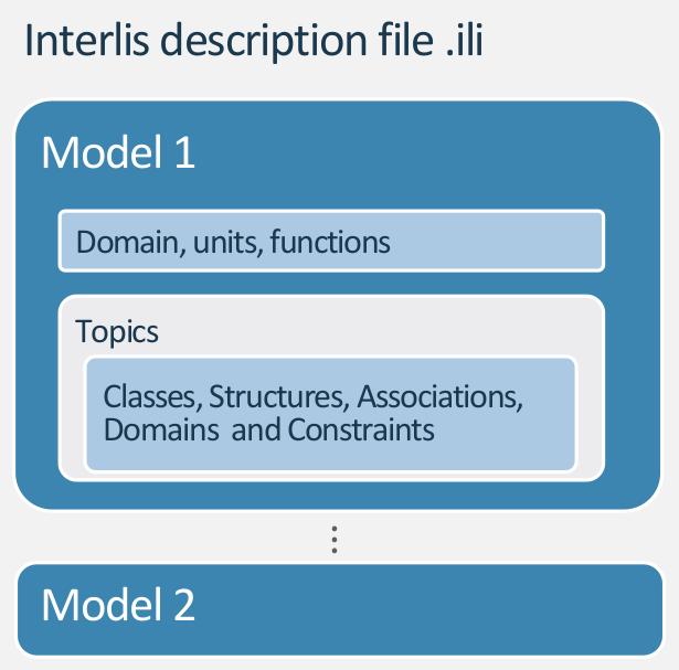
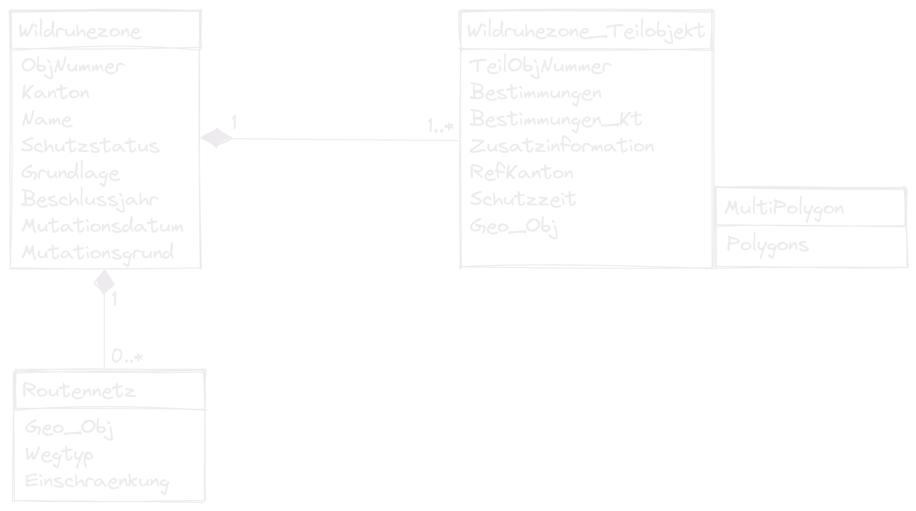
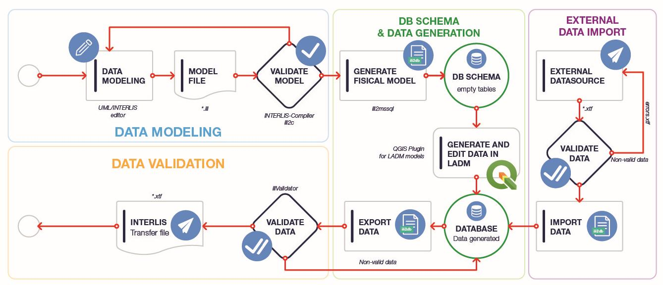
# What is INTERLIS? --- - INTER Land Information Systems - A data description language with special consideration of **geodata** - Object oriented and extendable - System neutral (platform independent) - Readable by humans and machines - Model driven approach <!-- [INTERLIS](https://www.interlis.ch/) (INTER Land Information Systems) is a data description language and a transfer format with special consideration of geodata. INTERLIS offers the possibility to describe spatial data precisely, to integrate them in conformity with the model and to exchange them easily among different users. INTERLIS has been bindingly anchored in Swiss geoinformation legislation since 2008. Since INTERLIS has been object-oriented since version 2, it can be extended very easily. This means that, for example, the federal government defines a model that the cantonal authorities can derive and extend according to their needs. - Supports Geometries - Since version 2 object oriented - perfect for data exchange between authorities. This is important since it's anchored in Swiss geoinformation legislation since 2008 to use INTERLIS. - Perfect for the discussion between ITs and thematic specialists - Strict division between the transfer part and the modeling part --> --- ## Model file and transfer data file The model is defined in INTERLIS language and stored in an `.ili` file. The data is in xml (considering the model) and stored as an `.xtf` file (former `.itf`). --- ## Why you could like INTERLIS You have your database schema in your poket. It's easy readable and precice. Thanks to the nice tools, it's easy to implement in your database and in QGIS. <!-- Compared to e.g. SQL Scripts you can simply extend it. --> --- # INTERLIS Modelling in 10 Minutes --- ## Model Structure  <!-- A model contains Units, Functions, Domains, Classes, Structures and Topic definitions. Contains all definitions to describe a part of the modeled reality. --> --- ``` INTERLIS 2.3; MODEL Wildruhezonen_LV95_V2_1 (de) AT "https://models.geo.admin.ch/BAFU/" VERSION "2020-04-21" = DOMAIN Punkt = GeometryCHLV95_V1.Coord2; TOPIC Wildruhezonen = CLASS Routennetz = Name : MANDATORY TEXT*80; END Routennetz; END Wildruhezonen; END Wildruhezonen_LV95_V2_1. ``` --- ## Classes **Syntax** ``` ClassDef = 'CLASS' Class-Name '=' { AttributeDef } 'END' Class-Name ';'. ``` **Example** ``` CLASS Wildruhezone = ObjNummer : MANDATORY 0 .. 9999; Name : MANDATORY TEXT*80; END Wildruhezone; ``` <!-- Classes are like templates to create objects (class elements) from. Or entities in the context of databases. They have properties described as attributes. --> --- ## Attributes **Syntax** ``` AttributDef = Attribute-Name : [MANDATORY] Type | DomainRef; DomainRef = [ Model-Name '.' [ Topic-Name '.' ] ] Domain-Name ``` **Example** ``` Name : MANDATORY TEXT*80; Schutzstatus : MANDATORY Wildruhezonen_Codelisten_V2_1.Codelisten.Schutzstatus_CatRef; ``` --- ## Structures **Syntax** ``` StructureDef = 'STRUCTURE' Struct-Name '=' { AttributeDef } 'END' Struct-Name ';'. ``` **Example** ``` STRUCTURE PolygonStructure = Polygon: SURFACE WITH (STRAIGHTS) VERTEX GeometryCHLV03_V1.Coord2 WITHOUT OVERLAPS > 0.001; END PolygonStructure; STRUCTURE MultiPolygon = Polygons: BAG {1..*} OF PolygonStructure; END MultiPolygon; ``` <!-- Formally similar to classes are Structures but factually they are more like types or value ranges. They describe how more complicated properties of objects are constructed. The structure elements, have no identity of their own, but are values of attributes of an object. So they cannot exist without belonging to an object of a class. --> --- ## Accociations **Syntax** ``` AssociationDef = 'ASSOCIATION' '=' { RoleDef } 'END' ';'. RoleDef = Role-Name '--' ClassRef ';'. ``` **Example** ``` ASSOCIATION RoutennetzWildruhezone = WRZ_Routennetz -- {0..*} Routennetz; WRZ -<#> {1} Wildruhezone; END RoutennetzWildruhezone; ``` --- ## Extends ``` CLASS Wildruhezone = ObjNummer : MANDATORY 0 .. 9999; Name : MANDATORY TEXT*80; END Wildruhezone; CLASS Wildruhezone (EXTENDED) = /** Zuordnung der Zielarten Schutzbestimmung zur Wildruhezone */ Zielart: GL_Wildruhezonen_Codelisten_V1.Codelisten.Zielarten_CatRef; END Wildruhezone; ``` <!-- Of course to extend classes, topics needs to be extended as well. And with the class attributes can be extended as well. --> --- ## Types of classes - Concrete - Abstract - Final - Derivate/Extended ``` CLASS Wildruhezone (ABSTRACT)= END Wildruhezone; ``` <!-- Keywords to enforce or prevent specialization --> --- ## What are catalogues? Catalogues are external codelists that can be used like `Enumerations` but less static. Catalogues are data but "belong" to the data model. <!-- You can use the "old" model but update your catalogue. --> --- ## Structure of a catalogue Catalogues base on the model `CatalogueObjects_V1` and extend the abstract classes and structures ``` CLASS Bestimmungen_Catalogue EXTENDS CatalogueObjects_V1.Catalogues.Item = Code : MANDATORY TEXT*5; Description : MANDATORY LocalisationCH_V1.MultilingualText; END Bestimmungen_Catalogue; STRUCTURE Bestimmungen_CatRef EXTENDS CatalogueObjects_V1.Catalogues.MandatoryCatalogueReference = Reference (EXTENDED) : MANDATORY REFERENCE TO (EXTERNAL) Bestimmungen_Catalogue; END Bestimmungen_CatRef; ``` --- ## Reference to the catalogue ``` CLASS Wildruhezone_Teilobjekt = Bestimmungen : MANDATORY Wildruhezonen_Codelisten_V2_1.Codelisten.Bestimmungen_CatRef; END Wildruhezone_Teilobjekt; ``` --- ## Have a look at a simple model ```none INTERLIS 2.3; MODEL Buildings (de) AT "mailto:dave@localhost" VERSION "2021-10-06" = IMPORTS Units; TOPIC Building_Parcel_Property = CLASS Parcel = Number : MANDATORY 1 .. 10000; END Parcel; CLASS Person = !!@ ili2db.dispName = "Family Name" Name : MANDATORY TEXT*255; !!@ ili2db.dispName = "First Name" First_Name : MANDATORY TEXT*255; END Person; ASSOCIATION Property = Person -- {1..*} Person; Parcel -- {0..*} Parcel; ownership_share : MANDATORY 0 .. 100 [Units.Percent]; END Property; END Building_Parcel_Property; END Buildings. ``` --- ## Have a look at the real model ```none INTERLIS 2.3; !! Version | Who | Modification !!---------------------------------------------------------------------------------------- !! 2019-10-30 | BAFU | Neue Version 2.0: Ergänzung optionales Attribut «RefKanton» (Klasse Wildruhezone_Teilobjekt) für einen Link zu weiteren kantonalen Informationen !! Übernommene Anpassungen aus Anhörung (FIG, Kantone) !! 2020-01-23 | BAFU | Multipolygone eingeführt und Datentyp Wildruhezone_Teilobjekt.Geo_Obj als MultiPolygon definiert !! 2020-04-21 | BAFU | Second Constraint in CLASS Wildruhezone_Teilobjekt adapted !!@ furtherInformation=https://www.bafu.admin.ch/geodatenmodelle !!@ technicalContact=mailto:gis@bafu.admin.ch !!@ IDGeoIV="195.1, 195.2" MODEL Wildruhezonen_Codelisten_V2_1 (de) AT "https://models.geo.admin.ch/BAFU/" VERSION "2020-01-23" = IMPORTS LocalisationCH_V1,CatalogueObjects_V1; DOMAIN TypID = OID TEXT*80; /* Modell für externe Codelisten, die anschliessend importiert werden in die Modelle *_LV03* und *_LV95" */ TOPIC Codelisten = BASKET OID AS TypID; OID AS TypID; CLASS Bestimmungen_Catalogue EXTENDS CatalogueObjects_V1.Catalogues.Item = Code : MANDATORY TEXT*5; Description : MANDATORY LocalisationCH_V1.MultilingualText; END Bestimmungen_Catalogue; CLASS Schutzstatus_Catalogue EXTENDS CatalogueObjects_V1.Catalogues.Item = Code : MANDATORY TEXT*3; Description : MANDATORY LocalisationCH_V1.MultilingualText; END Schutzstatus_Catalogue; CLASS Wegtyp_Catalogue EXTENDS CatalogueObjects_V1.Catalogues.Item = Code : MANDATORY TEXT*3; Description : MANDATORY LocalisationCH_V1.MultilingualText; END Wegtyp_Catalogue; STRUCTURE Bestimmungen_CatRef EXTENDS CatalogueObjects_V1.Catalogues.MandatoryCatalogueReference = Reference (EXTENDED) : MANDATORY REFERENCE TO (EXTERNAL) Bestimmungen_Catalogue; END Bestimmungen_CatRef; STRUCTURE Schutzstatus_CatRef EXTENDS CatalogueObjects_V1.Catalogues.MandatoryCatalogueReference = Reference (EXTENDED) : MANDATORY REFERENCE TO (EXTERNAL) Schutzstatus_Catalogue; END Schutzstatus_CatRef; STRUCTURE Wegtyp_CatRef EXTENDS CatalogueObjects_V1.Catalogues.MandatoryCatalogueReference = Reference (EXTENDED) : MANDATORY REFERENCE TO (EXTERNAL) Wegtyp_Catalogue; END Wegtyp_CatRef; END Codelisten; END Wildruhezonen_Codelisten_V2_1. !!@ furtherInformation=https://www.bafu.admin.ch/geodatenmodelle !!@ technicalContact=mailto:gis@bafu.admin.ch !!@ IDGeoIV="195.1, 195.2" MODEL Wildruhezonen_LV03_V2_1 (de) AT "https://models.geo.admin.ch/BAFU/" VERSION "2020-04-21" = IMPORTS GeometryCHLV03_V1,LocalisationCH_V1,CHAdminCodes_V1,Wildruhezonen_Codelisten_V2_1; TOPIC Wildruhezonen = DEPENDS ON Wildruhezonen_Codelisten_V2_1.Codelisten; DOMAIN /* Linien/Flächen ohne Kreisbogen */ Linie = POLYLINE WITH (STRAIGHTS) VERTEX GeometryCHLV03_V1.Coord2; Polygon = SURFACE WITH (STRAIGHTS) VERTEX GeometryCHLV03_V1.Coord2 WITHOUT OVERLAPS > 0.001; /* Definition von Multipolygonen, analog CHBase Geometry */ STRUCTURE PolygonStructure = Polygon: Polygon; END PolygonStructure; STRUCTURE MultiPolygon = Polygons: BAG {1..*} OF PolygonStructure; END MultiPolygon; /* Klasse für die gesamten Wildruhezonen */ CLASS Wildruhezone = ObjNummer : MANDATORY 0 .. 9999; Kanton : MANDATORY CHAdminCodes_V1.CHCantonCode; Name : MANDATORY TEXT*80; Schutzstatus : MANDATORY Wildruhezonen_Codelisten_V2_1.Codelisten.Schutzstatus_CatRef; Grundlage : MANDATORY TEXT*250; Beschlussjahr : MANDATORY INTERLIS.GregorianYear; Mutationsdatum : INTERLIS.XMLDate; Mutationsgrund : LocalisationCH_V1.MultilingualMText; END Wildruhezone; /* Klasse für die Wildruhezonen-Routen */ CLASS Routennetz = Geo_Obj : MANDATORY Linie; Wegtyp : MANDATORY Wildruhezonen_Codelisten_V2_1.Codelisten.Wegtyp_CatRef; Einschraenkung : TEXT*254; /* Ein Wegtyp mit Einschränkungen (W2) bedingt einen textlichen Eintrag im Attribut Einschraenkung. Für einen Wegtyp ohne Einschränkungen (W1) muss das Feld Einschraenkung leer sein. */ MANDATORY CONSTRAINT NOT (Wegtyp->Reference->Code == "W2") OR DEFINED (Einschraenkung); MANDATORY CONSTRAINT NOT (Wegtyp->Reference->Code == "W1") OR NOT (DEFINED (Einschraenkung)); END Routennetz; /* Klasse für Wildruhezonen-Teilflächen */ CLASS Wildruhezone_Teilobjekt = TeilObjNummer : MANDATORY TEXT*30; Bestimmungen : MANDATORY Wildruhezonen_Codelisten_V2_1.Codelisten.Bestimmungen_CatRef; Bestimmungen_Kt : LocalisationCH_V1.MultilingualMText; Zusatzinformation : TEXT*500; RefKanton : INTERLIS.URI; Schutzzeit : MANDATORY TEXT*250; Geo_Obj : MANDATORY MultiPolygon; /* Wenn Bestimmungen den Status "R900" oder "E900" haben, muss das Feld Bestimmungen_Kt gefüllt sein. Bei anderen Bestimmungen muss das Feld Bestimmungen_Kt leer sein. */ MANDATORY CONSTRAINT NOT (Bestimmungen->Reference->Code == "R900" OR Bestimmungen->Reference->Code == "E900") OR DEFINED (Bestimmungen_Kt); MANDATORY CONSTRAINT (Bestimmungen->Reference->Code == "R900" OR Bestimmungen->Reference->Code == "E900") OR NOT (DEFINED (Bestimmungen_Kt)); END Wildruhezone_Teilobjekt; ASSOCIATION RoutennetzWildruhezone = WRZ_Routennetz -- {0..*} Routennetz; WRZ -<#> {1} Wildruhezone; END RoutennetzWildruhezone; ASSOCIATION Wildruhezone_TeilobjektWildruhezone = WRZ_Teilobjekt -- {1..*} Wildruhezone_Teilobjekt; WRZ -<#> {1} Wildruhezone; UNIQUE WRZ->Kanton, WRZ->ObjNummer, WRZ_Teilobjekt->TeilObjNummer; /* Wenn Schutzstatus = S10 "rechtsverbindlich", dann dürfen nur Bestimmungen für rechtsvebindliche Wildruhezonen erfasst werden, also R*. Wenn Schutzstatus = S20 "empfohlen", dann dürfen nur Bestimmungen für empfohlene Wildruhezonen erfasst werden, also E*. */ MANDATORY CONSTRAINT NOT (WRZ->Schutzstatus->Reference->Code == "S10") OR (WRZ_Teilobjekt->Bestimmungen->Reference->Code == "R10" OR WRZ_Teilobjekt->Bestimmungen->Reference->Code == "R20" OR WRZ_Teilobjekt->Bestimmungen->Reference->Code == "R30" OR WRZ_Teilobjekt->Bestimmungen->Reference->Code == "R40" OR WRZ_Teilobjekt->Bestimmungen->Reference->Code == "R50" OR WRZ_Teilobjekt->Bestimmungen->Reference->Code == "R60" OR WRZ_Teilobjekt->Bestimmungen->Reference->Code == "R70" OR WRZ_Teilobjekt->Bestimmungen->Reference->Code == "R80" OR WRZ_Teilobjekt->Bestimmungen->Reference->Code == "R90" OR WRZ_Teilobjekt->Bestimmungen->Reference->Code == "R100" OR WRZ_Teilobjekt->Bestimmungen->Reference->Code == "R110" OR WRZ_Teilobjekt->Bestimmungen->Reference->Code == "R120" OR WRZ_Teilobjekt->Bestimmungen->Reference->Code == "R130" OR WRZ_Teilobjekt->Bestimmungen->Reference->Code == "R140" OR WRZ_Teilobjekt->Bestimmungen->Reference->Code == "R150" OR WRZ_Teilobjekt->Bestimmungen->Reference->Code == "R160" OR WRZ_Teilobjekt->Bestimmungen->Reference->Code == "R900"); MANDATORY CONSTRAINT NOT (WRZ->Schutzstatus->Reference->Code == "S20") OR (WRZ_Teilobjekt->Bestimmungen->Reference->Code == "E10" OR WRZ_Teilobjekt->Bestimmungen->Reference->Code == "E20" OR WRZ_Teilobjekt->Bestimmungen->Reference->Code == "E30" OR WRZ_Teilobjekt->Bestimmungen->Reference->Code == "E40" OR WRZ_Teilobjekt->Bestimmungen->Reference->Code == "E50" OR WRZ_Teilobjekt->Bestimmungen->Reference->Code == "E900"); END Wildruhezone_TeilobjektWildruhezone; END Wildruhezonen; END Wildruhezonen_LV03_V2_1. !!@ furtherInformation=https://www.bafu.admin.ch/geodatenmodelle !!@ technicalContact=mailto:gis@bafu.admin.ch !!@ IDGeoIV="195.1, 195.2" MODEL Wildruhezonen_LV95_V2_1 (de) AT "https://models.geo.admin.ch/BAFU/" VERSION "2020-04-21" = IMPORTS GeometryCHLV95_V1,LocalisationCH_V1,CHAdminCodes_V1,Wildruhezonen_Codelisten_V2_1; TOPIC Wildruhezonen = DEPENDS ON Wildruhezonen_Codelisten_V2_1.Codelisten; DOMAIN /* Linien/Flächen ohne Kreisbogen */ Linie = POLYLINE WITH (STRAIGHTS) VERTEX GeometryCHLV95_V1.Coord2; Polygon = SURFACE WITH (STRAIGHTS) VERTEX GeometryCHLV95_V1.Coord2 WITHOUT OVERLAPS > 0.001; /* Definition von Multipolygonen, analog CHBase Geometry */ STRUCTURE PolygonStructure = Polygon: Polygon; END PolygonStructure; STRUCTURE MultiPolygon = Polygons: BAG {1..*} OF PolygonStructure; END MultiPolygon; /* Klasse für die gesamten Wildruhezonen */ CLASS Wildruhezone = ObjNummer : MANDATORY 0 .. 9999; Kanton : MANDATORY CHAdminCodes_V1.CHCantonCode; Name : MANDATORY TEXT*80; Schutzstatus : MANDATORY Wildruhezonen_Codelisten_V2_1.Codelisten.Schutzstatus_CatRef; Grundlage : MANDATORY TEXT*250; Beschlussjahr : MANDATORY INTERLIS.GregorianYear; Mutationsdatum : INTERLIS.XMLDate; Mutationsgrund : LocalisationCH_V1.MultilingualMText; END Wildruhezone; /* Klasse für die Wildruhezonen-Routen */ CLASS Routennetz = Geo_Obj : MANDATORY Linie; Wegtyp : MANDATORY Wildruhezonen_Codelisten_V2_1.Codelisten.Wegtyp_CatRef; Einschraenkung : TEXT*254; /* Ein Wegtyp mit Einschränkungen (W2) bedingt einen textlichen Eintrag im Attribut Einschraenkung. Für einen Wegtyp ohne Einschränkungen (W1) muss das Feld Einschraenkung leer sein. */ MANDATORY CONSTRAINT NOT (Wegtyp->Reference->Code == "W2") OR DEFINED (Einschraenkung); MANDATORY CONSTRAINT NOT (Wegtyp->Reference->Code == "W1") OR NOT (DEFINED (Einschraenkung)); END Routennetz; /* Klasse für Wildruhezonen-Teilflächen */ CLASS Wildruhezone_Teilobjekt = TeilObjNummer : MANDATORY TEXT*30; Bestimmungen : MANDATORY Wildruhezonen_Codelisten_V2_1.Codelisten.Bestimmungen_CatRef; Bestimmungen_Kt : LocalisationCH_V1.MultilingualMText; Zusatzinformation : TEXT*500; RefKanton : INTERLIS.URI; Schutzzeit : MANDATORY TEXT*250; Geo_Obj : MANDATORY MultiPolygon; /* Wenn Bestimmungen den Status "R900" oder "E900" haben, muss das Feld Bestimmungen_Kt gefüllt sein. Bei anderen Bestimmungen muss das Feld Bestimmungen_Kt leer sein. */ MANDATORY CONSTRAINT NOT (Bestimmungen->Reference->Code == "R900" OR Bestimmungen->Reference->Code == "E900") OR DEFINED (Bestimmungen_Kt); MANDATORY CONSTRAINT (Bestimmungen->Reference->Code == "R900" OR Bestimmungen->Reference->Code == "E900") OR NOT (DEFINED (Bestimmungen_Kt)); END Wildruhezone_Teilobjekt; ASSOCIATION RoutennetzWildruhezone = WRZ_Routennetz -- {0..*} Routennetz; WRZ -<#> {1} Wildruhezone; END RoutennetzWildruhezone; ASSOCIATION Wildruhezone_TeilobjektWildruhezone = WRZ_Teilobjekt -- {1..*} Wildruhezone_Teilobjekt; WRZ -<#> {1} Wildruhezone; UNIQUE WRZ->Kanton, WRZ->ObjNummer, WRZ_Teilobjekt->TeilObjNummer; /* Wenn Schutzstatus = S10 "rechtsverbindlich", dann dürfen nur Bestimmungen für rechtsvebindliche Wildruhezonen erfasst werden, also R*. Wenn Schutzstatus = S20 "empfohlen", dann dürfen nur Bestimmungen für empfohlene Wildruhezonen erfasst werden, also E*. */ MANDATORY CONSTRAINT NOT (WRZ->Schutzstatus->Reference->Code == "S10") ORWildruhezone WRZ_Teilobjekt->Bestimmungen->Reference->Code == "R50" OR WRZ_Teilobjekt->Bestimmungen->Reference->Code == "R60" OR WRZ_Teilobjekt->Bestimmungen->Reference->Code == "R70" OR WRZ_Teilobjekt->Bestimmungen->Reference->Code == "R80" OR WRZ_Teilobjekt->Bestimmungen->Reference->Code == "R90" OR WRZ_Teilobjekt->Bestimmungen->Reference->Code == "R100" OR WRZ_Teilobjekt->Bestimmungen->Reference->Code == "R110" OR WRZ_Teilobjekt->Bestimmungen->Reference->Code == "R120" OR WRZ_Teilobjekt->Bestimmungen->Reference->Code == "R130" OR WRZ_Teilobjekt->Bestimmungen->Reference->Code == "R140" OR WRZ_Teilobjekt->Bestimmungen->Reference->Code == "R150" OR WRZ_Teilobjekt->Bestimmungen->Reference->Code == "R160" OR WRZ_Teilobjekt->Bestimmungen->Reference->Code == "R900"); MANDATORY CONSTRAINT NOT (WRZ->Schutzstatus->Reference->Code == "S20") OR (WRZ_Teilobjekt->Bestimmungen->Reference->Code == "E10" OR WRZ_Teilobjekt->Bestimmungen->Reference->Code == "E20" OR WRZ_Teilobjekt->Bestimmungen->Reference->Code == "E30" OR WRZ_Teilobjekt->Bestimmungen->Reference->Code == "E40" OR WRZ_Teilobjekt->Bestimmungen->Reference->Code == "E50" OR WRZ_Teilobjekt->Bestimmungen->Reference->Code == "E900"); END Wildruhezone_TeilobjektWildruhezone; END Wildruhezonen; END Wildruhezonen_LV95_V2_1. ``` <!-- Mention IMPORTS --> ---  --- ## Check out the real model extended for Glarus ```code INTERLIS 2.3; !! Version | Modification !!---------------------------------------------------------------------------------------- !! 2020-03-13 | Erste Modellversion; Import/Erweiterung MGDM BAFU !!@ IDGeoIV="195.1, 195.2" !!@ technicalContact=mailto:geoinformation@gl.ch !!@ furtherInformation=https://models.geo.gl.ch/pdf/GL_Wildruhezonen_V1.pdf MODEL GL_Wildruhezonen_Codelisten_V1 (de) AT "https://www.gl.ch" VERSION "2020-03-13" = IMPORTS CatalogueObjects_V1,Wildruhezonen_Codelisten_V2_1; TOPIC Codelisten EXTENDS Wildruhezonen_Codelisten_V2_1.Codelisten = /** Katalog der Zielarten Schutzbestimmung */ CLASS Zielarten_Catalogue EXTENDS CatalogueObjects_V1.Catalogues.Item = /** Bezeichnung der Zielarten */ Bezeichnung : MANDATORY TEXT; END Zielarten_Catalogue; STRUCTURE Zielarten_CatRef EXTENDS CatalogueObjects_V1.Catalogues.MandatoryCatalogueReference = Reference (EXTENDED) : MANDATORY REFERENCE TO (EXTERNAL) Zielarten_Catalogue; END Zielarten_CatRef; END Codelisten; END GL_Wildruhezonen_Codelisten_V1. !!@ IDGeoIV="195.1, 195.2" !!@ technicalContact=mailto:geoinformation@gl.ch !!@ furtherInformation=https://models.geo.gl.ch/pdf/GL_Wildruhezonen_V1.pdf MODEL GL_Wildruhezonen_V1 (de) AT "https://www.gl.ch" VERSION "2020-03-13" = IMPORTS GL_Wildruhezonen_Codelisten_V1,Wildruhezonen_LV95_V2_1; TOPIC Wildruhezonen EXTENDS Wildruhezonen_LV95_V2_1.Wildruhezonen = OID AS INTERLIS.UUIDOID; DEPENDS ON GL_Wildruhezonen_Codelisten_V1.Codelisten; CLASS Wildruhezone (EXTENDED) = /** Zuordnung der Zielarten Schutzbestimmung zur Wildruhezone */ Zielart: GL_Wildruhezonen_Codelisten_V1.Codelisten.Zielarten_CatRef; END Wildruhezone; END Wildruhezonen; END GL_Wildruhezonen_V1. ``` --- # INTERLIS implementation workflow and tools ---  (Graphic by landnetwork.ch) --- # ili2 Tools made by Eisenhut Informatik --- ## Compiler ili2c The INTERLIS Compiler checks an INTERLIS model if the constructs of the language INTERLIS were applied correctly. It reports syntactic errors in the model with the line number so that they can be corrected by the modeler. --- ## ili2fme and ili2db ili2pg, ili2gpkg and ili2fgdb are programs that write an INTERLIS transfer file according to an INTERLIS model into a database (PostgrSQL/PostGIS, GeoPackage or ESRI FileGDB) or create such a transfer file from a database. --- ## ilivalidator The ilivalidator tool checks whether data in the INTERLIS 1 and 2 transfer format (*.itf/*.xtf) complies with the associated model (*.ili). License terms and further information about the ilivalidator can be found here. --- # Swiss geodata repositories --- ## ilimodels.xml - Based on the model `IliRepository09` - Contains objects of the class `ModelMetadata` where a model name and a file path is defined - The files are on the same repository --- ## ilisites.xml - Based on the model `IliSite09` - Contains objects of the class `SiteMetadata` where path to other repositories are defined http://models.interlis.ch/ilisite.xml -> http://models.geo.kgk-cgc.ch/ilisite.xml -> http://models.geo.sh.ch/ilisite.xml [*Let's have a look*](http://models.interlis.ch/) ---